
by Mike Bailey
I am a retired Surveyor who spent his whole career (1965 to 2010) measuring and recording:
- Water depths, to enable safe navigation of ships and boats into harbours.
- Coastal features, such as shorelines and beaches, to monitor changes in depth that occur over time.
- Near shore constructions, such as sea walls, groynes wharves, piers and jetties and boat ramps to monitor their effect on the surrounding areas.
In order for these depth measurements to have any coherence they have to be related to a common reference level. In Australia this common reference level or Datum is the Australian Height Datum (AHD).
AHD is a mean sea level datum and was established by analysis of data from recording tide gauges which operate in ports around Australia and which in some cases have been operating for around a century. (see below) I have not found any proposal that this datum be changed due to the rising sea level.
AHD was adopted by the National Mapping Council in May 1971 as the datum to which all vertical control for mapping was to be referred.
(AHD71 is a surface that passes through approximate MSL realised between 1966 and 1968 at 30 tide gauges around the coastline. (From Australian tides manual).
Due to the fact that tidal ranges vary around the Australian coast, from very large ranges in ports such as Darwin and Broome who experience tidal ranges in the order of 10 metres, to almost no tidal fluctuation in Hobart, each port has established a local datum for charting which is known as Chart datum which in turn is related to AHD.
A charting datum, usually lowest astronomical tide (LAT), is stated to be a height below AHD and is essential for shipping and boating because the depth of water available in a channel or port at a particular time is the depth shown on the chart the plus the height of the tide. In order to plan shipping movements along with many other coastal pursuits and construction activities the tidal height at any given time needs to be known in advance so the calculation and publication of Tide Tables is part of commerce and the overall economy.
It is for these two reasons that great attention has been paid by maritime authorities to the accurate collection of tidal records following the establishment of any port so that there exists a pool of data which can be analysed to determine mean sea level and consequently monitor any changes that have occurred over time.
An appreciation of the degree of effort that goes into the accurate monitoring and analysis of tides can be seen by reading through the Australian tides manual. If sea levels around Australia have been rising significantly it would seem logical that Port Authorities would acknowledge this and plan accordingly. No mention of this is made in this publication, or any authoritative source that I can locate.
From a publication by the Department of Spatial Sciences. December 2010:
An examination of the Australian Height Datum
Michael Shaun Filmer
This thesis is presented for the degree of Doctor of Philosophy of Curtin University of Technology
MSL can also change over long periods (secular changes), which can occur on a global basis (eustatic changes; Pugh,1987 , (301), causing the vertical datum zero-reference to no longer be MSL. Estimates of global sea level rise indicate a 20th century increase of ∼1.7 mm year (Church and White 2006). The sea level change is thought to be the result of thermal expansion of the oceans, with some contribution from melting glaciers and ice caps (Church et al.2008)
This conclusion is from actual measurements from tide gauges not computer models.
From the Australian Academy of Science website:
Globally, sea levels are currently rising
For two thousand years before the mid-19th century, the long-term global sea-level change was small, only a few centimetres per century. Since then, the rate of rise has increased substantially; from 1900 to 2012, sea level rose by a global average of about 19 centimetres.
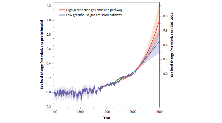
This is also 1.7 mm annually, or put another way, it will take 588 years to rise a metre using a linear projection. It goes on to state:
In the past 20 years, both satellite and coastal sea-level data indicate that the rate of rise has increased to about 3 centimetres per decade. A similarly high rate was experienced in the 1920 to 1950 period (Figure 6.1 [below]).
This could be interpreted as indicating that sea level change is cyclic not linear and projecting a linear or parabolic progression into the future is likely to be incorrect. The suggestion that sea levels “could” rise by a metre or more in the next century is pure conjecture not forecasting. As nearly all natural phenomena are cyclic it seems reasonable to suggest that sea levels would also be driven in the same manner.
Why then is there a sudden parabolic rise predicted as shown in the (Figure 6.1) particularly as there now seems to be a debate amongst the scientific community that we are entering a period of solar minimum which will cause the energy output of the sun to reduce and consequently the earth’s temperatures to fall. Again this is based on the observation of cycles.
This debate can be found on the NASA website.
The cyclic nature of sea level heights is further backed up by an extract from the NSW Environmental and Heritage website, under the heading “Measurement of sea level rise”. We find the following information which seems to validate the fact that sea level changes are cyclic rather than parabolic or linear.
Larger scale phenomena, like the El Niño Southern Oscillation (ENSO), the nodal tide and the Interdecadal Pacific Oscillation (IPO), can cause fluctuations in sea level spanning years to decades and are more difficult to isolate from sea level trends.
At multidecadal time scales sea level also varies with the IPO, which operates over time frames of 20 to 30 years (National Tidal Centre 2010; Holbrook, Goodwin et al 2010). This long period oscillation is a lengthy interdecadal fluctuation in atmospheric pressure and sea surface temperature. When the IPO is low, cooler than average sea surface temperatures occur over the central North Pacific, and vice versa. During the 20th century the IPO exhibited three major phases: it was positive (southeastern tropical Pacific warm) from 1922 to 1946 and 1978 to 1998, and negative between 1947 and 1976. During positive phases of IPO more El Niño like conditions prevail and sea levels in Eastern Australia are lower than average. During negative phases more La Nina like conditions prevail and sea levels are higher than average.
Again this conclusion is reached using actual measurements not computer models.
Below is one of many scare stories that have proved to be incorrect.
U.N. Predicts Disaster if Global Warming Not Checked
PETER JAMES SPIELMANN June 30, 1989
UNITED NATIONS (AP) – A senior U.N. environmental official says “entire nations could be wiped off the face of the Earth by rising sea levels if the global warming trend is not reversed by the year 2000. ”
“Coastal flooding and crop failures would create an exodus of ‘eco- refugees,’ threatening political chaos”, said Noel Brown, director of the New York office of the U.N. Environment Program, or UNEP.
He said: “governments have a 10-year window of opportunity to solve the greenhouse effect before it goes beyond human control.
“As the warming melts polar icecaps, ocean levels will rise by up to three feet, enough to cover the Maldives and other flat island nations, Brown told The Associated Press in an interview on Wednesday.”
30 years on this has clearly not happened. Are the current scare articles any different?
The chart shows sea levels rising after the 1850s ‘Little Ice Age’ which conforms with a regular solar cycle.
When the effects of the ‘Grand Solar Minimum’ become evident we can expect the sea level to fall accordingly, regardless of CO2 levels.