
By Wyss Yim
The University of Hong Kong
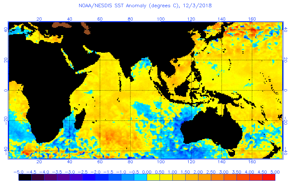
Patches of abnormally hot seawater beneath the ocean surface referred to as Blobs are naturally generated by submarine volcanic eruptions. A recent example is the North Pacific Blob1 which caused weird weather conditions accompanied by major ecological changes in the Pacific northeast including two years without winters in 2013 and 20142. This was featured as a ‘heat wave’ in the September 2016 issue of National Geographic and was used to support the anthropogenic global warming alarm. However, based on the study of available information including satellite and ARGO data buoy records, the release of geothermal heat from the Nishinoshima volcanic eruption 940 km south of Tokyo3 from March 2013 to August 2015 was identified the culprit4,5.
This study examines the climatic impacts of another Blob created by the eruption of a new submarine volcano on the floor of southwest Indian Ocean off Mayotte in the Comoros. Subsequent ocean circulation changes led to the development of an exceptionally strong positive phase of the Indian Ocean Dipole (IOD)6. Regional climatic impacts in the southwest Indian Ocean included torrential rainfall and the establishment of a new record of 10 intense tropical cyclones during the 2018-2019 season. In the East Indian Ocean, the corresponding cooling of sea-surface waters gave rise to severe drought conditions in land areas of Indonesia and Australia.
Marc Chaussidon, director of the Institute of Geophysics in Paris was responsible for the discovery of the new as yet unnamed submarine volcano off the southeast coast of Mayotte7. Through looking at seafloor maps and a recently concluded mission, Chaussidon identified a new submarine volcano 800 meters high and 5 kilometers across rising above the ocean floor erupted within 6 months after November 2018 between Africa and Madagascar.

Multibeam sonar mapping of the sea floor indicated as much as 5 cubic kilometers of magma was erupted onto the seafloor. Based on the Volcanic Explosivity Index used for the measurement of terrestrial eruptions, the scale is 5 which is moderately strong. The sonar was able to detect plumes of gas-rich water rising from the flanks and central part of the volcano.
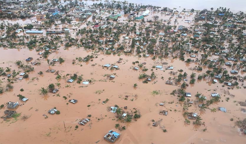
An examination of NOAA satellite sea-surface anomalies map archives has revealed that Blob was already well developed in early December 2018, the beginning of the southern hemisphere summer. This hot seawater assisted by solar heating was responsible for setting the new record of 10 intense tropical cyclones during the 2018-2019 season. Out of 10, the most severe was intense tropical cyclone Idai. The total cost of damage was estimated to exceed US$2 billion and the minimum death toll was 1007 because many bodies have not been recovered. Storm surge flooding was the worst on record with the destruction of 111,163 homes and damage to 112,735 houses in central and western Mozambique8.

| Name | Date | Wind speed km/hr |
Pressure hPa |
Countries affected |
Damage/death toll |
| Alcide
Kenanga Cilida Funani Gelena Haleh
Idai
Savannah Joaninha Kenneth |
5-12 Nov.
16-22 Dec. 16-24 Dec. 3-10 Feb. 4-14 Feb. 28 Feb.- 7 Mar. 4-16 Mar.
17-19 Mar. 18-30 Mar. 21-29 Aper. |
165
185 215 195 205 175
195
165 185 215 |
965
942 940 940 942 945
940
962 939 934 |
Agaléga/Madagascar/Tanzania -MauritiusRodriguesMadagascar/Mauritius/Rodrigues- Mozambique, – Rodrigues Seychelles, |
–
– Minimal Minimal US$1 – >US$2 – – US$10.5 >US$100 |
Summary table of the 10 intense tropical cyclones during the record breaking 2018-2019 season in southwest Indian Ocean. Source: Wikipedia9

Previous work10 has demonstrated the importance of Indian Ocean variability in southeast Australia’s worst droughts. This is supported by the present study by the coincidence in timing of the Blob in causing positive IOD conditions during the southern hemisphere summer.
In late May, 2019, as a result of an extremely dry summer Sydney Water, Australia announced the enforcement of water restrictions throughout the greater Sydney area. As of May 29, 2019, Greater Sydney water supply levels are 53.4%, which is significantly lower than May 2018, in which supply levels were 73% in major catchments. These restrictions began on June 1, 2019.
In conclusion, severe weather events including tropical cyclones, droughts and floods may be caused by Blobs formed by the natural release of geothermal heat through submarine volcanic eruptions in combination with the sun to warm the surface waters of regional oceans. This warming in the West Indian Ocean was responsible for the development of a strong positive phase in the IOD resulting in oceanic and atmospheric circulation changes regionally which cannot be accounted for by carbon dioxide variations. Currently the natural release of geothermal heat into oceans is underestimated by the scientific community and may also represent a significant proportion of the missing heat in oceans proposed to explain the post-1998 pause in global temperature rise.
References-
-
- https://en.wikipedia.org/wiki/The_Blob_(Pacific_Ocean).
- Welch, C. 2016. Heat wave. National Geographic, September 2016, 54-75.
- https://en.wikipedia.org/wiki/Nishinoshima_(Ogasawara).
- Yim, W. 2016. Explanation for the northern Pacific Blob. Imperial Engineer Autumn 2016, 15.
- Yim, W. 2017. Geothermal heat: an episodic heat source in oceans. Imperial Engineer Spring 2017, 14-15.
- https://en.wikipedia.org/wiki/Indian_Ocean_Dipole.
- https://www.sciencemag.org/news/2019/05/ship-spies-largest-underwater-eruption-ever.
- https://en.wikipedia.org/wiki/Cyclone_Idai.
- https://en.wikipedia.org/wiki/2018%E2%80%9319_South-West_Indian_Ocean_cyclone_season.
- Ummenhofer, C.C. 2009. What causes southeast Australia’s worst droughts? Geophysical Research Letters 36(4): L04706. Bibcode: 2009GeoRL..36.4706U. doi:10.1029/2008GL036801.
Common sense at last. The core of Planet Earth is now estimated at 6,000 degrees C – hotter than the surface of the Sun. Life on this planet exists on a thin crust averaging 35 km thick under the continents and 5 km thick under the sea. Interior heat migrates outwards, mainly through volcanic vents. There are only a few thousand surface volcanoes but hundreds of thousands of sub-sea volcanoes where the crust is thinner. The temperature of the sea dictates the amount of dissolved gas, and you don’t boil a cup of water by waving a hair dryer over it – an immersion heater is far more effective. The planet also contains immeasurable quantities of carbon dioxide and methane which are well described in a book by Thomas Gold, ‘The deep, hot biosphere’.
80% of our thin gaseous atmosphere is within an 18 km thick Troposphere. It is little wonder that carbon dioxide levels follow, and don’t lead climatic temperatures which are governed by solar and cosmic cycles which dictate volcanic and earthquake activity. Note the increase of such events at the full moon when tides are high and gravimetric stresses on the Earth’s crust are higher. Check http://www.copyright.net.au for publications on this.
People are influenced daily by the controlling media which is bombarding and influencing the minds of the masses. What happened to common sense? It truly is a tragedy to witness how the average person today relies and believes the media B.S. instead of engaging their own brain.
The Earth is over 4 Billion earth years old constantly changing. All neighboring planets in this part of our galaxy are with no exception influenced by the changes and activities of our sun. We are nearing the end of the age of Pisces ( Kaliuga)and are moving into the next era known as Aquarius with its entrance beginning in 2150 A.D. For the next 2150 years ( til 4300 A.D. ) Earth will undergo great changes as recorded in ancient texts, and shown in the inner chambers of all the pyramids around this world may they be underwater or above ground.
Earth’s magnetic poles are becoming more and more unstable as the sun’s electromagnetic frequencies are on the rise, heating up our Earth magma. As the Earth’s inner magma heats up it is also expanding, pushing up against the Earth’s crust, causing a steady increase in volcanic eruption, earth quakes, tectonic pressure along the ring of fire, cracks, giant sinkholes, earth movements, coastlines sliding into the ocean, new islands forming, others sinking, etc.
These changes cause massive amounts of water evaporating up into the air, releasing torrential rain, snow, ice or hail over areas not used to these kinds of weather causing severe flooding . Since 2012 the increase of tornadoes, cyclones, hurricanes and sever storms have been registered world wide. We are still in a solar minimum heading toward the next solar maximum with its beginning in 2020.
For a better understanding, the ‘Milankovich Circle’, and the ‘Diehold Foundation’ ( 1,2,3,4,5,) should be informative to get prepared no matter were we are living. Our North pole has been moving eastward for quite some years now.
Because I have attended a symposium where Wyss spoke, I suggested this might have happened when the volcano was discovered, shortly after the unusual and exceptional cyclonic weather in this region. So after Wyss did the donkey work and tracked down the effects in the satellite and other records I also worked out the energy involved. 5Km3 of magma cooling to a solid through a delta T of 1200 degrees, equates to 20 ExaJoules deposited in the oceans, in the 6 months it took to form from nothing. The heat is clearly rising rapidly to the surface, visible on ultrasound as a plume, (the usual physics except in climate science where heat sinks and hides in the cooler and much larger heat capacity oceans, under the consensual physics of reverse convection that we must also believe. ENERGY: That is equivalent to 5,000 Megatonnes of nukes, or a bit more than the entire USA’s annual electrical energy use (5,500TWh).
NB: My interest here is the steady average oceanic warming by the 100,000 such large volcanoes under the oceans, which is also very variable on Milankovitch time scales and a capable and well documented source of adequate and variable enough heat to create interglacial levels of overall ocean temperature rise on its own, using the simple maths above and Fourier analysis of the magma record. Paper here. Still a w.i.p. Just the facts, and the real physics. Contains no models, forcing, or consensus. http://dx.doi.org/10.2139/ssrn.3259379
I have followed this eruption event for some time and noted the extreme weather events affecting
the countries around the Indian Ocean and yet we are still being told that eg. the Pakistani floods are down to human actions.
There was an eruption offshore Tonga in January ’22 and extreme weather events occurred on the east coast of Australia. Friends visited Byron Bay late last year and noted sea temps of 25C which to them was very unusual.
However, this information is not getting through and the world is still being told climate change is to do with humans actions. Why?